Soaring over the Canadian Prairies requires sharp observation, precise aerodynamics, and understanding weather cues. Since flatlands have weaker, dispersed thermals and fewer terrain features, you must be attentive to subtle atmospheric signals like cloud formations, wind shifts, and air temperature changes. Optimizing your glider’s aerodynamics and using weather forecasts can help locate rising air. Mastering these skills turns flatland thermalling into an achievable experience—if you keep exploring, you’ll uncover even more techniques to succeed.
Key Takeaways
- Flatland thermalling over the Canadian Prairies requires keen observation of subtle atmospheric cues like wind shifts and cloud patterns.
- Accurate weather forecasting and cloud formation analysis help identify potential thermal zones in the open prairie landscape.
- Glider aerodynamics, including optimal wing shape and control responses, are vital for effective soaring in flat terrain.
- Monitoring environmental signs, such as wind variation with altitude, enhances thermal detection and sustained flight.
- Combining weather insights with precise flying techniques transforms flat prairie thermalling into a successful soaring experience.
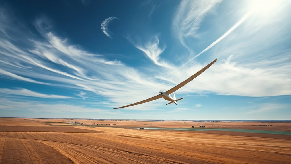
Flatland thermalling might seem impossible at first glance, but skilled pilots have mastered the art of gaining altitude over flat terrain. When soaring over the vast Canadian Prairies, you’ll quickly realize that understanding glider aerodynamics is essential. Unlike mountainous regions where lift is more predictable, flatlands require a deep knowledge of how your glider interacts with the atmosphere. You need to maximize every aspect of your aircraft’s design—like wing shape, aspect ratio, and control surfaces—to make the most of the subtle thermal currents that form over the plains. These thermals are often weaker and more dispersed, so your ability to read and adapt to the glider’s aerodynamics determines your success in climbing.
Mastering glider aerodynamics transforms flatland thermalling into an achievable adventure.
Weather forecasting becomes your most valuable tool in flatland thermalling. Precise forecasts help you identify potential lift zones, such as heating from sun-warmed ground or localized convection, which can generate thermals even in the absence of obvious terrain features. You’ll want to pay attention to temperature gradients, wind patterns, and cloud formations. Clear skies with cumulus clouds often indicate thermal activity, but in the flatlands, the lift can be subtle and inconsistent. By staying updated on the latest weather models, you can plan your flight path to maximize your chances of catching rising air. Forecasters can tell you when a warm front is moving in or if a stable high-pressure system is dominating the area, both of which influence thermal development.
As you fly, you’ll learn to interpret the subtle cues offered by the environment. Changes in wind direction at different altitudes, shifts in cloud cover, or even the way your glider responds to minor adjustments in pitch and bank can reveal where thermals are forming. Your ability to read these signs and adjust accordingly hinges on a solid understanding of glider aerodynamics. For example, knowing how your wing’s lift-to-drag ratio varies with airspeed helps you stay within the ideal speed range for thermal circling. The more you practice, the better you become at feeling the glider’s response to the air’s currents, allowing you to stay aloft longer and climb higher despite the flat terrain’s challenges. Additionally, employing proper thermal detection techniques can significantly improve your success rate in flatland soaring.
In essence, flatland thermalling demands a blend of technical knowledge, strategic planning, and intuitive flying. By mastering glider aerodynamics and utilizing accurate weather forecasting, you harness the ability to soar over the Canadian Prairies, turning what seems impossible into an exhilarating reality.
Frequently Asked Questions
What Safety Equipment Is Essential for Prairie Thermalling?
You should always carry essential safety equipment for prairie thermalling, including emergency gear like a first aid kit and a parachute. Make sure to have reliable communication devices such as a radio or mobile phone to stay in contact with others. These tools help you respond quickly to unexpected situations, ensuring your safety during the flight. Always double-check your equipment before takeoff and stay prepared for any emergencies.
How Do Weather Conditions Affect Thermalling on Flatlands?
Weather conditions greatly influence your thermalling experience on flatlands. Cloud cover determines the availability of lift, with cumulus clouds signaling strong thermals. Wind patterns affect your stability and control, as steady winds help you stay in lift zones, while gusty or changing winds can be risky. Always check the weather forecast, observe cloud formations, and monitor wind conditions before you soar to guarantee safety and maximize your chances of finding good thermals.
What Are the Best Times of Day for Thermalling?
You’ll find the best times for thermalling are late morning and early afternoon when the sun angle is high enough to create strong thermal updrafts with longer thermal duration. As the sun climbs, it heats the ground more evenly, enhancing lift. Stay alert during this period, as the thermals are more consistent, giving you ample time to circle and gain altitude before afternoon sun dips, reducing thermal strength.
How Can Pilots Identify Reliable Thermals in Flat Terrain?
You’ll notice that about 90% of thermals are associated with specific cloud formations, like cumulus clouds, which act as natural thermal indicators. To identify reliable thermals in flat terrain, look for these clouds, especially their edges and bases, which often mark rising air. Additionally, observe dust devils or smoke patterns that drift upward, signaling thermal activity. Trust these visual cues to help you find consistent lift in open landscapes.
Are There Specific Techniques for Maintaining Altitude Over Prairie Landscapes?
You can maintain altitude over prairie landscapes by focusing on cloud spotting and terrain reading. Look for cumulus clouds indicating thermals and observe their movement to stay aloft. Scan the terrain for subtle changes, like wind ripples or dust devils, that signal rising air. Constantly adjust your position based on these visual cues, and keep an eye on your variometer to make the most of the thermals you find.
Conclusion
As you glide across the endless Canadian prairies, the sky becomes your playground, and flatland thermalling transforms into a dance with the wind. Embrace the vastness around you, feeling as free as a bird riding invisible currents. Remember, every lift is like a secret whispered by the earth below, guiding you higher. So, keep your wings steady and your spirit adventurous—because in these open skies, you’re truly alive, soaring over a sea of gold.