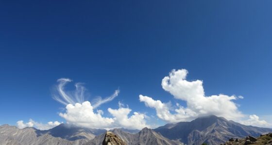

Looking at cumulus cloud shapes can tell you a lot about lift quality. Tall, well-defined clouds with cauliflower tops show strong upward air currents, indicating unstable conditions and active convection. Flatter, diffuse clouds suggest stable air with limited vertical movement, meaning weaker lift. Sharp, crisp edges signal ongoing upward motion, while fuzzy edges hint at stabilization. If you want to understand how these shapes signal weather potential, keep exploring how cloud forms reflect atmospheric dynamics.
Key Takeaways
- Tall, well-defined cumulus clouds indicate strong updrafts and high lift potential.
- Flatter, diffuse clouds suggest stable air with limited vertical movement.
- Cauliflower-like tops signal active convection and vigorous vertical lift.
- Sharp, crisp cloud edges reflect ongoing upward motion and atmospheric instability.
- Cloud flattening or dissipation indicates decreasing lift and increased atmospheric stability.

Cumulus clouds come in a variety of shapes, and their forms directly influence the lift quality they provide. When observing cloud formation, you can often gauge how much lift is available for soaring or flying. The shape and structure of these clouds reflect the underlying atmospheric stability, which determines whether conditions are conducive to rising air currents. If a cumulus cloud appears tall and well-defined, it suggests strong updrafts, indicating unstable atmospheric conditions that promote vigorous cloud development. Conversely, flatter, more diffuse cumulus clouds typically signal stable air, where lift is limited and vertical movement is weak.
Understanding what these shapes reveal about lift quality requires paying attention to how the clouds grow and change. When a cloud has a cauliflower-like top with a sharp, cauliflower-like appearance, it usually indicates active convection with enough energy to sustain significant vertical lift. These clouds are often tall, their tops reaching high altitudes, showcasing the presence of strong updrafts. This kind of cloud formation means the atmosphere is unstable, allowing warm air to rise rapidly and create excellent lift conditions for gliders and pilots. On the other hand, if the cloud appears more rounded and lacks a well-defined top, it suggests that vertical movement is limited. It also indicates a stable atmosphere, where clouds are not reaching high altitudes and lift is weaker.
You can also observe the overall texture and edges of the cloud. Sharp, crisp edges often indicate fresh, active cloud formation with ongoing upward motion. In contrast, fuzzy or blurred edges suggest that the cloud has stabilized or that the lift has diminished. When the atmospheric stability shifts toward stability, the cloud formation tends to flatten out or dissipate, signaling reduced lift potential. Recognizing these cloud signals is crucial in understanding atmospheric stability, which can help forecast weather conditions more accurately. Additionally, analyzing the cloud growth patterns can reveal subtle shifts in atmospheric conditions that might precede significant weather changes, aiding in early prediction and safety planning. Knowing how cloud shapes relate to climate patterns can also contribute to broader understanding of environmental impacts and sustainable practices.

Cloud Investigator Weatherproof Identification Tool for Kids. Learn Different Types of Clouds and Predict The Weather. Portable Handheld Tool with Chain for Easy Carrying on a Backpack or Belt Loop
WEATHERPROOF DURABILITY: Made from 24PT thick laminated material, this tool is built to withstand the elements.
As an affiliate, we earn on qualifying purchases.
As an affiliate, we earn on qualifying purchases.
Frequently Asked Questions
How Do Wind Patterns Influence Cumulus Shape Development?
Wind patterns play a vital role in shaping cumulus clouds during cloud formation. When winds are strong and turbulent, they stretch and distort the clouds, creating towering, well-defined shapes. On the other hand, gentle winds lead to more rounded, uniform cumulus forms. You’ll notice that changing wind directions and speeds influence whether clouds appear fluffy and stable or elongated and dynamic, revealing the intensity and stability of the atmospheric lift.
Can Cloud Color Indicate Lift Strength?
Yes, cloud color can indicate lift strength. Bright white clouds usually suggest strong lift, as sunlight reflects off the dense water droplets. Darker or gray clouds often mean weaker lift, with less sunlight penetration. If the cloud appears more luminous and vibrant, it indicates active upward motion. Conversely, dull or darker clouds signal diminishing lift. Paying attention to cloud color helps you assess the current or upcoming weather conditions effectively.
Do All Cumulus Shapes Signal Upcoming Storms?
Not all cumulus shapes signal upcoming storms. Cloud formation varies, and while towering, cauliflower-like cumulonimbus clouds often indicate storm potential, smaller, fair-weather cumulus generally don’t. Recognizing different shapes helps with storm prediction, but it’s essential to bear in mind other factors like cloud height and weather patterns. So, keep an eye on the overall cloud development, as not every cumulus shape points to imminent storms.
How Quickly Do Cumulus Shapes Change During the Day?
Cumulus shapes can change quite quickly during the day, reflecting ongoing cloud evolution. You’ll notice them grow taller and more developed during peak heating, then dissipate or transform as the heat lessens. This is part of the daily cloud cycles, where warm surface temperatures fuel convection, causing rapid shape changes. Staying observant helps you understand these dynamic shifts, giving you a better sense of upcoming weather changes based on the evolving cloud formations.
Are There Regional Differences in Cumulus Cloud Formations?
Yes, regional climate and altitude variation influence cumulus cloud formations. In coastal areas, you’ll see more towering, fluffy clouds due to moisture from ocean air, while inland regions might display flatter, more dispersed cumulus shapes. Higher altitudes often produce smaller, more delicate clouds, whereas lower altitudes generate larger, puffy formations. These regional differences reflect local temperature, humidity, and atmospheric stability, shaping how cumulus clouds develop across different landscapes.

BTMETER Anemometer Handheld Wind Speed Meter, BT-816B Mini Digital Air Flow Meter with LCD Backlight/Wind Chill & Temp, Max/Avg/Current Mode to Measure Air Flow Velocity for Sailing Drone Golf HVAC
✅【Highly Accurate Digital Wind Meter】Portable Wind measure device with a sensitive temperature sensor & 7 smooth fan shaft…
As an affiliate, we earn on qualifying purchases.
As an affiliate, we earn on qualifying purchases.
Conclusion
By observing cumulus shapes, you can gain insights into lift quality. Rounded, well-formed clouds often indicate strong, stable updrafts, while flatter, wispy clouds suggest weaker lift. Think of these shapes as visual clues—just like reading a weather map. When you understand these signs, you’re better equipped to anticipate flight conditions, making your flying experience safer and more predictable. So, pay attention to cloud shapes; they tell a story about the atmosphere’s lift potential.

The Cloud Collector's Handbook
As an affiliate, we earn on qualifying purchases.
As an affiliate, we earn on qualifying purchases.

Newentor Weather Station Wireless Indoor Outdoor Thermometer, Color Display Digital Weather Thermometer with Atomic Clock, Barometric Pressure, Forecast Station with Adjustable Backlight, Black
[7.5" LCD Screen Weather Stations] Newentor temperature&humidity monitor with large color display, which shows comprehensive information: inside outside…
As an affiliate, we earn on qualifying purchases.
As an affiliate, we earn on qualifying purchases.