
Mountain cross-country flying differs from flatland flying because you must constantly manage altitude changes, navigate unpredictable terrain, and adapt to rapidly changing weather conditions. You rely heavily on visual cues and terrain features for navigation, while ensuring safety margins from peaks and cliffs. Advanced planning and aircraft performance awareness are essential for avoiding hazards. If you’re curious how to navigate these challenges effectively, you’ll discover more strategies and tips as you explore further.
Key Takeaways
- Mountain cross-country flying involves rapid altitude adjustments and terrain awareness due to variable elevation changes.
- Navigating mountainous terrain requires reliance on visual cues and strategic route planning around obstacles.
- Weather conditions are more unpredictable, with hazards like turbulence, wind shear, and mountain waves more prevalent.
- Pilots must develop mental maps and adapt navigation strategies to account for terrain features and limited visual references.
- Aircraft performance limits and safety considerations are more critical in mountains, demanding heightened situational awareness.

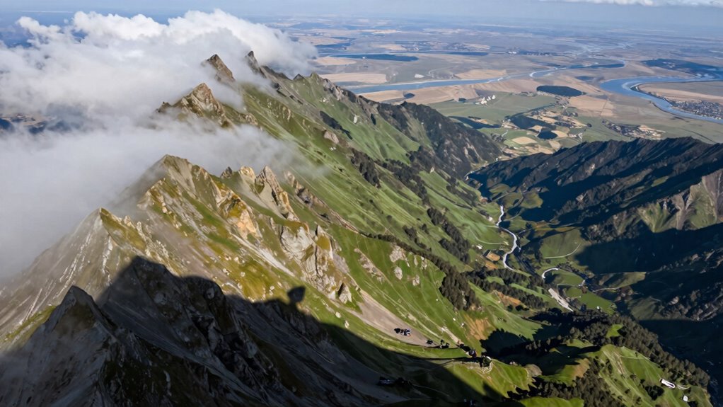
Flying cross-country in mountainous terrain presents unique challenges compared to flatland flying. The most immediate difference you’ll notice is the altitude challenges. Unlike open plains, where the terrain remains relatively level, mountains introduce sudden changes in elevation that demand constant altitude adjustments. You must be vigilant about maintaining a safe clearance from peaks, ridges, and cliffs, especially when flying in less-than-ideal weather conditions. As you navigate through this rugged landscape, you’ll need to carefully monitor your altitude to avoid inadvertently descending into dangerous terrain. This requires precise planning, frequent altitude checks, and a thorough understanding of your aircraft’s performance limits at various elevations. Additionally, understanding terrain features can significantly improve your ability to navigate safely and efficiently in mountain environments.
Terrain navigation becomes considerably more complex in the mountains. You can’t rely solely on visual cues like straight-line routes or familiar landmarks, as the terrain can be unpredictable and heavily obstructed by peaks and valleys. Instead, you must develop a mental map of the terrain, constantly adjusting your course to stay clear of obstacles. This often involves flying along ridgelines, valleys, or specific terrain features that serve as navigational aids. Unlike flatland flying, where you can often fly directly to your destination with minimal concern for elevation, mountain flying demands a strategic approach. You’ll need to plan your route carefully, considering factors like wind patterns, potential downdrafts, and the possibility of sudden weather changes that can obscure visibility or cause turbulence.
Weather plays a vital role in mountain cross-country flights. Conditions can change rapidly, with wind shear, turbulence, and mountain waves presenting additional hazards. You must be prepared for these elements by understanding local weather patterns and being ready to adjust your plans accordingly. Mountain terrain also tends to generate more turbulent air, especially near ridges and steep slopes, which can challenge aircraft control and passenger comfort.
Ultimately, flying cross-country in mountainous terrain requires heightened situational awareness, advanced planning, and a thorough understanding of your aircraft’s capabilities. You need to be proactive in managing altitude challenges and terrain navigation, always staying ahead of potential hazards. By doing so, you’ll guarantee a safer, more efficient flight, and you’ll gain the confidence that comes with mastering the complexities of mountain flying. The thrill of traversing rugged landscapes is unmatched, but it demands respect, preparation, and skill.
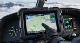
mountain cross-country flight navigation tools
As an affiliate, we earn on qualifying purchases.
As an affiliate, we earn on qualifying purchases.
Frequently Asked Questions
What Specific Skills Are Essential for Mountain Cross-Country Flying?
You need strong altitude management and terrain awareness skills for mountain cross-country flying. You must constantly monitor your altitude to avoid obstacles and rapidly changing terrain. Recognizing terrain features and potential hazards allows you to make timely adjustments, ensuring safety. Mastering these skills helps you navigate complex mountain landscapes confidently, keeping your flight smooth and secure. Staying alert and prepared is essential for successful mountain cross-country adventures.
How Do Weather Conditions Differ Between Mountain and Flatland Flying?
Did you know mountain flying encounters 50% more weather hazards than flatland flying? You’ll notice weather conditions differ greatly; mountain air can be unpredictable with rapidly changing winds and turbulence, creating altitude challenges. In contrast, flatland flying offers more stable, predictable weather patterns. When flying in mountains, you must stay alert for sudden storms, updrafts, and downdrafts, which demand quick decision-making and careful navigation to stay safe.
What Types of Aircraft Are Best Suited for Mountain Cross-Country Flights?
You should choose high-performance aircraft like taildraggers, lightweight singles, or bush planes for mountain cross-country flights. These aircraft excel in mountain terrain thanks to their excellent aircraft performance, agility, and ability to handle short, rough runways. Their powerful engines and sturdy build let you navigate steep climbs, unpredictable air currents, and uneven terrain, making them ideal for safely tackling the challenges of mountain cross-country flying.
Are There Unique Safety Concerns in Mountain Flying Compared to Flatland?
You face unique safety concerns in mountain flying, with altitude challenges being a major factor—aircraft performance drops considerably at higher elevations. Terrain awareness is critical; you must constantly watch for unpredictable terrain and changing weather conditions. Unlike flatland flying, these risks demand diligent pre-flight planning, monitoring your altitude, and staying alert to avoid sudden obstacles. Proper training and awareness can help you navigate these hazards safely.
How Does Navigation Differ in Mountainous Terrain Versus Flat Areas?
In mountainous terrain, you must prioritize altitude awareness and terrain recognition to navigate safely. Unlike flat areas, you’ll rely heavily on visual cues to identify peaks, ridges, and valleys, adjusting your altitude constantly to avoid obstacles. You should plan your route carefully, use topographical maps, and stay vigilant for changing terrain features. This proactive approach helps you maintain safe clearance and stay oriented amid the complex landscape.
Conclusion
So, next time you take to the skies, remember that mountain cross-country isn’t just about conquering peaks—it’s about embracing the unpredictable. Ironically, what seems exhilarating and free often demands more caution and respect than flatland flying. It’s a humbling reminder that adventure comes with its risks, and sometimes, the greatest thrill is knowing you’ve faced the wild and lived to tell the tale. After all, isn’t that what makes it all so worth it?