
Thunderstorm anvils can be both an opportunity and a red flag. They indicate strong updrafts and storm development, helping you spot severe weather early. A towering, spreading anvil often signals a powerful storm with potential hazards like hail or tornadoes. However, not all anvils mean danger—some are harmless cirrus clouds. To stay safe, learn how to interpret anvil size, shape, and behavior. If you’re curious about identifying actual threats, keep exploring these signals further.
Key Takeaways
- Tall, sharp-edged anvil clouds often indicate severe storms with strong updrafts, signaling potential hazards like hail or tornadoes.
- Widespread, spreading anvils can show storm maturation or weakening, serving as a warning to monitor conditions closely.
- Anvil height exceeding 40,000 feet typically correlates with increased storm severity and danger.
- Anvil shape and size changes, such as rapid spreading or overshooting tops, can signal storm intensification.
- Recognizing visual cues and utilizing technology like radar and lightning detection helps determine whether an anvil signals opportunity or threat.
What Are Thunderstorm Anvils and How Do They Form

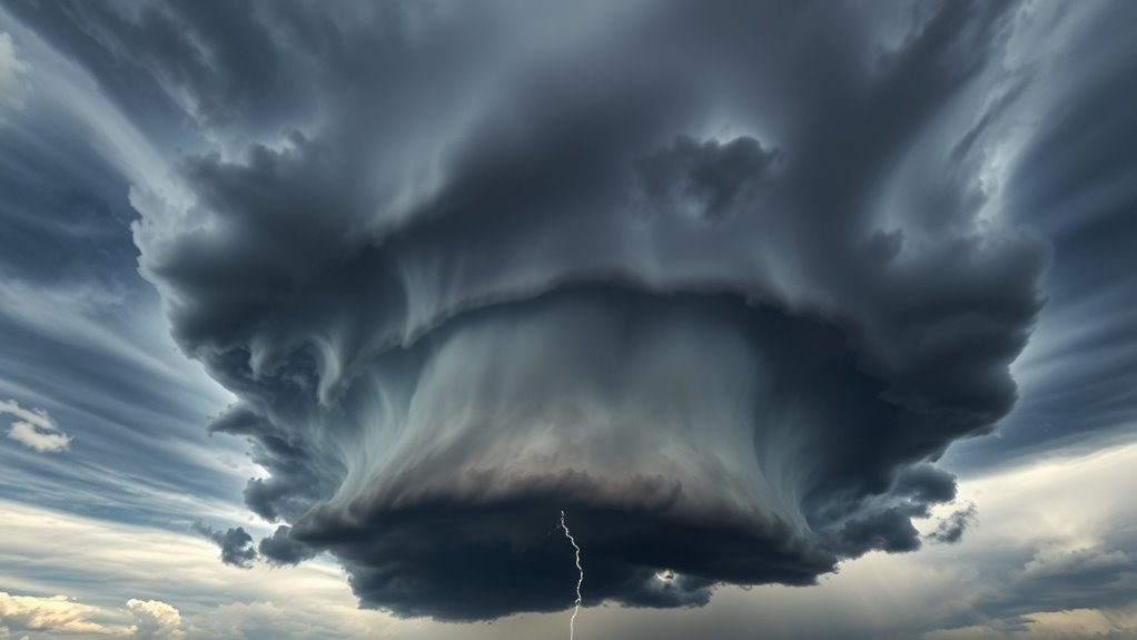
Thunderstorm anvils are the large, flat-topped cloud formations that spread out horizontally at the top of a thunderstorm. They form through a process called anvil formation, where the rising air within a storm reaches the tropopause, the boundary between the troposphere and stratosphere. Once the cloud reaches this level, the upward motion slows, causing the cloud top to spread outward instead of rising further. This creates the characteristic anvil shape. Recognizing anvil formation is essential for storm forecasting because it indicates a mature and potentially severe thunderstorm. As the anvil spreads, it can signal strong updrafts and the likelihood of hail, high winds, or tornadoes. Understanding how anvils develop helps meteorologists predict storm intensity and movement more accurately, especially since storm safety depends on timely identification of such features.
The Visual Characteristics of Anvil Clouds
Anvil clouds are easily recognizable by their distinctive, broad, and flat-topped appearance that spreads out horizontally at the top of a thunderstorm. Their cloud color varies from bright white to dark gray, depending on the sunlight and moisture content. The anvil texture can be smooth or billowy, revealing different cloud dynamics. You might notice:
Anvil clouds feature broad, flat tops with bright edges and billowy textures indicating storm intensity.
- Bright, luminous edges where sunlight catches the cloud’s top
- Darker, shadowed areas indicating denser cloud regions
- A wispy, fibrous look in the cloud’s upper layers
- The presence of mottled or streaked patterns on the anvil surface
- Variations in cloud color suggesting moisture levels or storm intensity
These visual cues help you interpret the storm’s development and potential severity, making anvil clouds both fascinating and informative. Incorporating natural materials and paying attention to the cloud’s shape and texture can enhance your understanding of storm behavior.
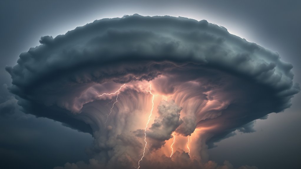
Anvils and Storm Intensity: What the Height and Shape Reveal

The height of an anvil often indicates how strong the storm is, with taller clouds signaling more intense updrafts. Similarly, the shape of the anvil can reveal the storm’s potential for severity and its direction. By observing these features, you can better understand the storm’s power and likely impact. Glycolic acid in skincare, for example, enhances skin radiance by promoting cell turnover and can help reduce the appearance of pores, much like how analyzing anvil features helps gauge storm intensity.
Anvil Height and Power
Have you ever wondered what the height and shape of a storm’s anvil reveal about its intensity? The height of the anvil indicates how powerful the storm is, as taller clouds suggest stronger updrafts and more cloud condensation. When an anvil reaches higher altitudes, it signals that the storm is likely more severe. The formation process involves vigorous updrafts pushing moisture and cloud condensation to the upper atmosphere, creating a broad, flat top. Key indicators include:
- Tall, expansive anvil height signals strong storm energy
- Anvil spreading indicates intense updrafts and cloud condensation
- Higher anvils often correlate with severe weather potential
- Vertical growth reflects storm strength
- Flattened or spreading anvils may suggest the storm is weakening or changing over
- The shape and height of the anvil can also be affected by the storm’s outflow and wind shear conditions.
Understanding these signs helps you gauge storm power and potential severity.
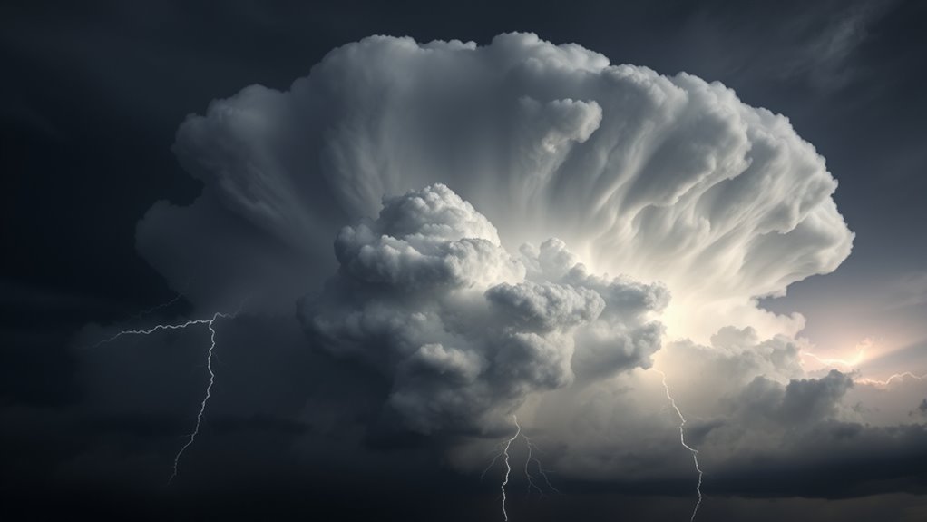
Shape Signals Storm Strength
Seeing the shape of a storm’s anvil provides valuable clues about its strength and development. The cloud dynamics behind storm formation influence the anvil’s shape, revealing how intense the storm might become. A broad, flat anvil suggests strong updrafts and vigorous storm growth, indicating a mature and potentially severe system. Conversely, a narrower anvil often points to a weaker storm with limited cloud dynamics. The height and spread of the anvil reflect how efficiently the storm’s energy is being released into the upper atmosphere. By observing these shapes, you can gauge storm strength before it reaches the ground, helping you anticipate possible severe weather. In fundamental terms, the anvil’s form is a visual cue that reveals the storm’s underlying cloud dynamics and potential impact. Contrast ratio also plays a role in how vividly the storm’s features appear, influencing our perception of its severity.
Differentiating Between Safe and Dangerous Anvil Displays
You can often tell if an anvil storm is dangerous by looking at the cloud height and shape. Tall, anvil-shaped clouds with sharp, well-defined edges usually signal severe weather, while lower, wispy anvils tend to be calmer. Pay attention to the surrounding weather patterns to better assess whether the display indicates a safe or threatening situation. Additionally, observing seasonal variations can help you understand how different times of year influence storm development and safety considerations.
Cloud Height Indicators
Cloud height indicators are vital tools for distinguishing between safe and dangerous anvil displays during thunderstorms. By observing the cloud height and anvil altitude, you can gauge the storm’s severity. Typically, a high, towering cloud indicates stronger updrafts and potential turbulence, signaling danger. Conversely, lower, flatter anvils suggest a less intense storm. Pay attention to these signs:
- Very tall cloud tops exceeding 40,000 feet
- Anvil spreading widely at high altitudes
- Rapidly rising cloud height over time
- Anvil shape becoming more diffuse
- Cloud top temperature readings indicating extreme altitude
- Juice cleansing and other dietary changes can influence overall health and resilience during stormy weather. Monitoring these indicators helps you assess whether an anvil is a red flag or an opportunity for safe observation. Understanding cloud height and anvil altitude provides essential insights into storm intensity and potential hazards.
Anvil Shape Clues
The shape of anvil clouds provides valuable clues about storm safety. Look closely at the anvil’s shape to gauge danger. A broad, spreading anvil often indicates the storm is weakening or moving away, especially if the anvil color appears lighter or more diffuse. Conversely, a sharply pointed or towering anvil suggests intense updrafts and a potentially hazardous storm. Pay attention to the storm’s direction; if the anvil is expanding toward your location, it signals the storm is approaching or intensifying. Darker anvil colors, especially with a gray or black hue, often mean heavy rain or hail is imminent. Recognizing these shape clues helps you decide whether to seek shelter or stay alert, making anvil shape a crucial part of storm awareness. Additionally, understanding how AI safety measures are developed and monitored can improve our response to emerging storm patterns and ensure better preparedness.
Weather Pattern Context
How can you tell if an anvil’s display indicates safety or danger? By considering the broader weather pattern context, you can better interpret storm behavior. Storm tracking helps you see if the storm is intensifying or weakening, while cloud composition reveals its potential severity. Dangerous anvils often appear with rapidly growing, towering clouds and signs of active convection. Safe displays typically show stable, leveling clouds with little vertical development. Watch for these cues:
- Rapid storm movement or expansion
- Dark, dense cloud bases
- Signs of new storm development nearby
- Persistent anvil growth over hours
- Changes in storm direction or speed
Understanding weather pattern context helps you differentiate between a threatening storm and a benign one, guiding your safety decisions effectively. Urban pursuits in Harrisburg can also influence local weather patterns and should be considered when assessing storm risks.
The Role of Anvil Clouds in Severe Weather Prediction

Anvil clouds, the towering, flat-topped extensions of thunderstorms, serve as vital indicators for severe weather development. Their formation reflects changes in cloud structure and atmospheric stability. When you see anvil clouds spreading widely, it signals strong updrafts and the potential for severe weather. These clouds form when moist air rises rapidly, reaching the tropopause, where cloud formation stabilizes and spreads out. Observing anvil shape and size helps predict storm intensity and duration. Additionally, understanding the research-backed content behind cloud behavior can improve forecasting accuracy.
Technological Tools for Monitoring Anvil Development

Advancements in technology have considerably improved our ability to monitor anvil cloud development in real time. With tools like lightning detection systems, you can track lightning activity associated with storm growth, providing early warnings. Radar imaging offers detailed visuals of storm structure, revealing anvil expansion and movement. These tools help you recognize critical signs indicating storm severity or potential for severe weather. Key features include:
Real-time tech tools like lightning detection and radar imaging enhance storm monitoring and safety.
- Real-time lightning detection for activity spikes
- High-resolution radar imaging to track anvil size and shape
- Doppler radar to assess wind patterns within storms
- Satellite imagery for large-scale cloud development
- Automated alerts based on specific anvil growth patterns
Together, these technologies give you an exhaustive picture, enabling timely decisions and enhancing safety during thunderstorms.
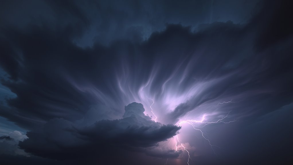
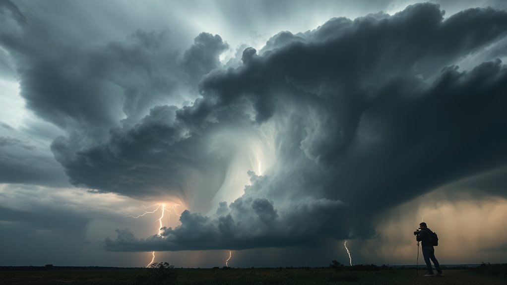
Interpreting Anvil Signals: When to Take Shelter

Recognizing the signals from anvil clouds is essential for deciding when to seek shelter, as these features often indicate an approaching severe storm. During storm chasing or cloud photography, pay attention to rapid changes in the anvil’s shape, size, and movement. An anvil spreading out quickly or developing an overshooting top suggests intensification and potential severe weather. Bright, anvil lightning or a towering, anvil-shaped cloud can also warn you to take cover. If you notice the anvil extending toward your location or darkening skies nearby, it’s time to seek shelter immediately. Understanding these signals helps you avoid danger while still enjoying storm chasing adventures or capturing dramatic cloud images. Always prioritize safety when anvil signals indicate severe storm activity is imminent.
Common Myths and Misconceptions About Anvil Clouds
Many people believe that all towering cloud formations with broad, flat tops are dangerous storms ready to strike, but this isn’t always true. This myth-busting helps clarify misconceptions about anvil clouds. Some misinterpretation myths include:
- Assuming every anvil indicates imminent severe weather
- Believing all anvils produce lightning or hail
- Thinking an anvil’s size reflects storm strength
- Confusing harmless cirrus clouds with storm anvils
- Overestimating the threat based solely on cloud appearance
Understanding that not every anvil signifies danger is vital. Anvil clouds can be part of benign cloud formations or developing storms. Recognizing these myths helps you interpret weather more accurately and avoid unnecessary alarm or complacency. Accurate myth busting ensures you make informed decisions about storm safety.
Preparing for Storms: Using Anvil Cues for Safety
When you see an anvil cloud forming overhead, it’s a good idea to stay alert and prepare for potential weather changes. Anvil clouds, classified as cumulonimbus, signal that a storm is developing, making them essential cues for storm chasing and safety. Recognize the cloud’s shape, size, and movement—rapid expansion or a spreading anvil suggests intensifying weather. Use this cloud classification as an early warning to seek shelter or move to safer locations. Paying attention to anvil cues helps you anticipate lightning, strong winds, or hail. Always monitor local weather updates and avoid risky areas if storm activity increases. Understanding these signals allows you to act swiftly, reducing danger and ensuring safety during turbulent weather conditions.
Frequently Asked Questions
Can Anvil Clouds Indicate Upcoming Tornado Formation?
You might wonder if anvil cloud patterns can signal tornado formation. While anvil clouds often indicate strong thunderstorms, they don’t necessarily predict tornadoes. In tornado prediction, meteorologists analyze multiple factors, including storm rotation and other weather patterns, rather than relying solely on anvil cloud shapes. Recognizing these clouds is helpful, but you should always stay alert to official warnings and additional signs for accurate tornado preparedness.
How Do Anvil Cloud Formations Differ Globally?
Globally, cloud formations differ due to diverse climate conditions and atmospheric moisture. You’ll notice towering, textured anvil clouds in tropical regions, where warm, moist air fuels fierce storm systems. In contrast, arid areas produce sparse, straggly clouds, while temperate zones showcase varied, voluminous cloud patterns. These differences reflect local weather patterns and atmospheric moisture levels, revealing how Earth’s climate creates unique cloud architectures across the globe.
Are All Large Anvils Associated With Severe Weather?
Not all large anvils are linked to severe weather, but they often indicate strong updrafts in cloud formation. When you see a sprawling anvil, it suggests intense convection that could develop into storms. While some anvils signal potential for severe weather, others may form without causing danger. For accurate weather prediction, consider other factors like wind shear and humidity, as not every big anvil means trouble.
What Climate Factors Influence Anvil Cloud Development?
You wonder what climate factors influence anvil cloud development? You should consider how anvil cloud chemistry affects cloud growth, how anvil cloud altitude determines storm reach, and how temperature, humidity, and wind shear all shape their formation. These factors control the stability of the atmosphere, the energy available, and the storm’s potential severity. By understanding these influences, you can better interpret anvil cloud behavior and its implications for weather patterns.
How Can I Distinguish Between Benign and Threatening Anvils Visually?
To distinguish between benign and threatening anvils, look closely at cloud shape variations, color, and brightness cues. Threatening anvils often have sharply defined edges, towering structures, and may exhibit anvil glows indicating intense activity. Benign anvils tend to be more diffuse with softer edges and duller colors. Bright, white, or illuminated anvil tops suggest strong updrafts and potential storm development, so pay attention to these visual cues to assess threat levels.
Conclusion
So, next time you see a majestic anvil cloud looming overhead, remember it’s not just nature’s artwork—it’s basically the storm’s warning sign. Ignoring it might turn you into a weather statistic faster than you can say “lightning strike.” So, keep your eyes peeled, your shelter ready, and your weather app on standby. After all, misreading anvil signals isn’t just risky; it’s the ultimate way to turn a beautiful sky into a lightning-fast disaster.