
Understanding atmospheric convection involves seeing how warm, moist air heats at the surface and rises, cooling as it ascends, which causes water vapor to condense into clouds. This process creates cumulus clouds, which grow vertically as convection continues. The cycle progresses from initial rise to mature clouds that can produce rain or thunderstorms, reflecting the dynamic nature of the atmosphere. To grasp the full cloud life cycle, exploring further details reveals how these processes shape weather patterns daily.
Key Takeaways
- Warm surface air heats and rises, initiating convection and cloud formation through moisture condensation.
- As air ascends, it cools to dew point, causing water vapor to condense into visible cumulus clouds.
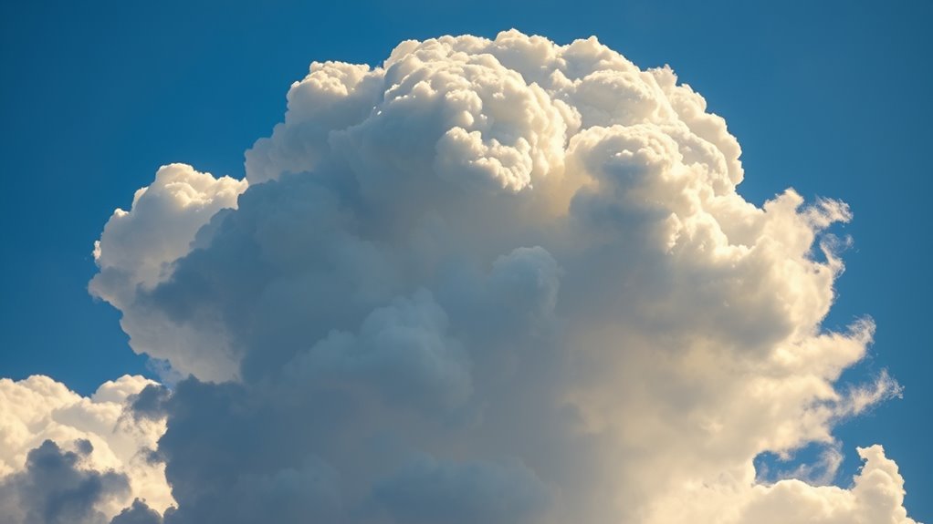
- Cloud growth occurs via continuous updrafts, increasing vertical size and developing characteristic cauliflower shapes.
- During the mature stage, clouds reach higher altitudes, potentially producing precipitation and thunderstorms.
- The cloud’s life cycle continues until dissipation or escalation into severe weather, driven by ongoing atmospheric convection.
Atmospheric convection is a fundamental process that drives weather patterns and influences climate. When you observe the sky and see a cumulus cloud forming, you’re witnessing the result of convection processes at work. Convection occurs when warm air near the Earth’s surface heats up, becomes less dense, and rises through cooler, denser air above. As this warm air ascends, it cools and reaches a point where the moisture it contains condenses into tiny water droplets, leading to cloud formation. This cycle is central to understanding how clouds develop and evolve over time.
Atmospheric convection is key to weather patterns, forming clouds as warm air rises and cools, leading to condensation and cloud development.
During the initial stage of convection, the sun’s energy heats the ground unevenly, creating pockets of warmer air that start to rise. You’ll notice these rising air parcels carry moisture upward, and as they ascend, the temperature drops. When the air cools to its dew point, water vapor condenses onto tiny particles called aerosols, forming the visible part of the cloud. This is the beginning of the cumulus cloud’s life cycle. The process is continuous — as long as the surface remains warm and moist, convection processes keep the air rising, feeding the cloud with moisture and energy.
As the cloud grows, the convection process intensifies. The rising warm air continues to carry moisture upward, and the cloud can expand vertically. You might observe the cloud developing a cauliflower-like appearance, characteristic of cumulus clouds. During this stage, strong updrafts sustain the cloud’s growth, and the cloud’s structure becomes more defined. The temperature difference between the rising air and its surroundings encourages further condensation, which in turn fuels continued convection. The cloud’s size and shape reflect the strength and stability of the convection processes happening within it.
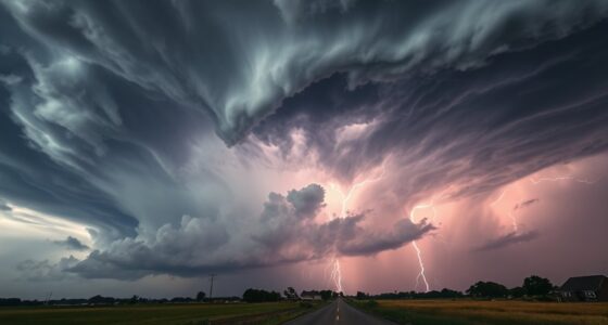
Eventually, if the convection persists and the cloud becomes tall enough, it can reach the altitude where temperatures are cold enough to produce precipitation. This marks the transition to a mature stage, where the cloud may produce rain or thunderstorms. The convection processes driving the cloud’s development now involve not just rising warm air but also complex interactions with surrounding air masses and atmospheric conditions. At this point, the cloud’s life cycle might end with dissipation or intensify into more severe weather phenomena, depending on the energy and moisture available.
Understanding these convection processes and how they produce cloud formation offers insight into the dynamic nature of our atmosphere. It’s a constant cycle driven by the Sun’s energy, shaping weather and climate patterns in real time. Watching a cumulus cloud grow and change is witnessing the powerful and intricate dance of atmospheric convection at work.
Top picks for "understand atmospheric convection"
Open Amazon search results for this keyword.
As an affiliate, we earn on qualifying purchases.
Frequently Asked Questions
How Does Atmospheric Convection Influence Global Climate Patterns?
You influence global climate patterns through atmospheric convection by engaging in ocean-atmosphere interactions, where warm ocean waters fuel convection, affecting weather systems worldwide. Convection feedbacks intensify this process, leading to more extreme weather and altering climate patterns over time. By understanding how convection transfers heat and moisture, you can better predict changes in climate, especially in regions where ocean and atmosphere interactions are strongest, shaping our planet’s future.
What Role Do Aerosols Play in Cloud Formation?
Imagine a city with pollution particles drifting into the sky. Aerosol effects, like these particles, facilitate cloud condensation by providing surfaces for water vapor to gather. They help form clouds faster and can produce smaller droplets, influencing cloud longevity and reflectivity. In this way, aerosols play a vital role in cloud formation by acting as nuclei, directly impacting weather patterns and climate through cloud properties.
Can Convection Be Predicted Accurately Over Long Periods?
Long-term forecasting of convection variability is challenging, but you can improve accuracy with advanced models and climate data. While predictions over extended periods aren’t perfect due to the complex nature of atmospheric processes, combining satellite observations, historical trends, and meteorological models helps you identify patterns. This allows you to anticipate convection activity more reliably, though uncertainties remain, especially with changing climate influences impacting convection behavior over time.
How Do Different Cloud Types Interact Within Convection Processes?
Think of cloud interactions as a lively dance floor, where different cloud types move and influence each other. During convection, cumulus clouds can trigger the formation of stratocumulus or cumulonimbus, affecting cloud evolution. These interactions shape the weather we experience, with each cloud type playing a role in energy transfer and moisture distribution. Recognizing how they interact helps us better understand the complex processes driving atmospheric convection.
What Are the Impacts of Convection on Weather Extremes?
Convection can substantially impact weather extremes, leading to storm intensification and increased precipitation variability. As warm air rises, it fuels stronger storms, making them more severe and prolonged. You might experience sudden heavy rains or hail, and more intense thunderstorms. These extremes result from convection’s ability to concentrate energy vertically, amplifying storm activity and causing unpredictable, often dangerous, weather patterns that can affect communities and ecosystems alike.
Conclusion
Now that you understand the life cycle of a cumulus cloud, you see how energy rises, how moisture gathers, and how clouds grow and fade. You recognize the power of warm air, the importance of humidity, and the cycle of convection at play. By observing these processes, you grasp the dynamic nature of our atmosphere. Embrace your newfound knowledge, and see every cloud as a reminder of the vibrant, continual dance of atmospheric convection happening all around you.