
To navigate mountain wave hazards effectively, use forecast models that simulate airflow over terrain, predicting turbulence and wind shear zones. Focus on key features like vertical velocity data, terrain interaction, and wind patterns at different altitudes. These models help you identify potential turbulence areas and wind shear, allowing you to plan safer routes and adjust altitudes accordingly. Continuing with these insights will equip you with an all-encompassing approach to mountain flying safety.
Key Takeaways
- Utilize high-resolution atmospheric models to simulate mountain wave activity and identify turbulence-prone zones.
- Analyze wind shear indicators within forecast models to anticipate sudden wind changes affecting flight safety.
- Review vertical velocity data to detect mountain wave oscillations and associated turbulence regions.
- Incorporate terrain interaction algorithms that account for airflow disturbances over mountain ranges.
- Continuously update forecasts with real-time data to refine turbulence and mountain wave predictions for flight planning.
Understanding Mountain Wave Phenomena

Have you ever wondered why mountain waves form and how they affect weather patterns? These waves develop when stable air flows over mountain ranges, creating oscillations that extend downwind. Understanding mountain wave phenomena is essential for turbulence prediction, especially for pilots navigating near mountainous terrain. Wind shear plays a significant role in wave formation, occurring when wind speed or direction changes sharply with altitude. This shear amplifies wave energy, increasing turbulence risks. Recognizing these conditions helps forecast potential hazards and improves safety. Mountain waves can produce severe turbulence, affecting aircraft performance and passenger comfort. By analyzing wind shear and airflow patterns, meteorologists can better predict when and where mountain waves will intensify, giving pilots vital information to plan safer routes and avoid dangerous turbulence zones. Additionally, advancements in AI security can aid in developing more accurate and timely weather forecasting models, enhancing pilot safety during mountain flying conditions.
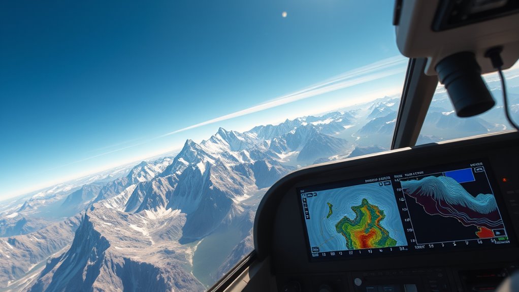
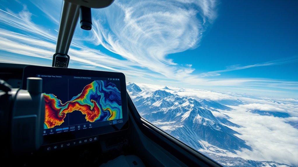
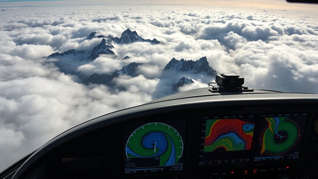
Key Features of Forecast Models

Forecast models for mountain waves rely on advanced algorithms that simulate atmospheric conditions with high spatial and temporal resolution. These models excel at turbulence prediction, helping you identify areas where turbulence may intensify. They analyze wind patterns, stability, and airflow interactions with terrain to forecast potential disturbances. A key feature is their ability to detect wind shear, which can cause sudden changes in wind speed or direction, critical for pilot awareness. By capturing the dynamics of mountain-induced airflow, these models provide detailed insights into when and where turbulence and wind shear are likely to occur. This helps you anticipate hazardous conditions, plan safer routes, and adjust your flying techniques accordingly. Accurate forecasting of turbulence and wind shear enhances safety and efficiency in mountain flying. Additionally, understanding the weight of wind turbine blades and their impact on airflow can inform your awareness of atmospheric disturbances near wind farms, contributing to more comprehensive mountain wave forecasts.
Interpreting Model Data for Flight Planning

To effectively use model data for flight planning, you need to understand how to interpret the detailed outputs these models provide. Focus on turbulence prediction, as mountain waves can generate severe turbulence that impacts safety and comfort. Look for indications of sudden changes in wind speed or direction, which signal wind shear—an important factor during ascent, descent, or when flying near mountain ridges. Pay attention to vertical velocity data, which helps identify wave activity and potential turbulence zones. Recognize that strong wind shear often correlates with turbulent areas, so plan altitude adjustments accordingly. Additionally, understanding chemical properties of atmospheric particles can enhance your interpretation of weather patterns and turbulence. By analyzing these parameters, you can anticipate hazardous conditions, optimize your route, and enhance safety during mountain flying. Proper interpretation transforms raw data into actionable insights.
Integrating Forecasts Into Your Pre-Flight Routine
Integrating forecasts into your pre-flight routine is essential for ensuring safety and efficiency when flying through mountainous terrain. Understanding weather patterns helps you anticipate mountain wave activity and make informed pilot decisions. Consistent review of forecast models allows you to identify potential turbulence or rotor zones, reducing surprises during flight. Use the table below to systematically incorporate forecast data:
| Step | Action | Purpose |
|---|---|---|
| Check weather models | Review mountain wave forecasts | Identify turbulence risk |
| Assess wind patterns | Observe wind strength/direction | Plan safe routes |
| Evaluate stability | Determine atmospheric stability | Decide on flight timing |
| Confirm updates | Ensure forecast accuracy before departure | Optimize decision making |
This approach keeps you proactive, enhancing safety by aligning your pilot decision making with current mountain weather patterns.
Practical Tips for Mountain Flying Safety
Flying in mountain terrain demands careful attention to safety practices, as the challenging environment can quickly turn hazardous. To minimize risks, focus on turbulence prediction by analyzing weather patterns before and during your flight. Study recent weather pattern analysis to identify potential turbulence areas caused by mountain waves or wind shifts. Always check updated forecasts, paying close attention to wind speeds and directions at different altitudes. Maintain a safe altitude, especially when flying through known turbulence zones, and be ready to adjust your route if conditions worsen. Use real-time weather data and stay alert to changing conditions. Remember, proactive planning and continuous monitoring are key to safe mountain flying. Prioritize safety, and never underestimate the power of thorough weather analysis. Understanding atmospheric phenomena can help pilots better anticipate turbulence caused by mountain waves and improve flight safety.
Frequently Asked Questions
How Accurate Are Current Mountain Wave Forecast Models?
Current mountain wave forecast models are quite reliable, but their accuracy depends on factors like model calibration and data resolution. You’ll find that well-calibrated models with high-resolution data can predict wave patterns more precisely, helping you avoid turbulence. However, lower resolution data or poor calibration can lead to less accurate forecasts. Always consider these factors when planning your flight to guarantee safety and ideal routing through mountainous terrain.
Can Models Predict Individual Wave Severity for Specific Locations?
While no model can promise perfect predictive granularity, current mountain wave forecast models do offer valuable insights into wave severity at specific locations. You should understand that model precision varies, and forecasts are best used as guides rather than guarantees. By combining these tools with your experience, you can better anticipate potential wave conditions, but always stay prepared for unexpected changes in severity.
What Are the Limitations of Existing Mountain Wave Forecasting Tools?
You might wonder about the limitations of existing mountain wave forecasting tools. These models often struggle with resolution, making it hard to predict small-scale wave details accurately. Data latency also impacts their reliability, as delays in data updates can lead to outdated forecasts. As a result, you can’t always depend on these tools for precise, real-time information, especially in complex terrain or rapidly changing weather conditions.
How Often Should Pilots Update Mountain Wave Forecasts Before Flights?
They say, “A stitch in time saves nine,” and the same applies to weather updates. You should update mountain wave forecasts at least every hour before your flight, especially if weather patterns are changing quickly. Rely on real-time pilot alerts and current data to stay ahead of sudden shifts. This way, you can make informed decisions, ensuring safety and comfort during your flight through unpredictable mountain terrains.
Are There Regional Differences in the Reliability of Forecast Models?
You’ll find that forecast reliability varies regionally due to differences in climate and topography, impacting forecast variability. In mountainous areas with complex terrain, models may be less accurate, so you should cross-reference multiple sources and stay alert for updates. Coastal regions might have more consistent predictions, but always consider local climate factors. Adjust your planning accordingly, especially when flying in areas with known forecast challenges.
Conclusion
By mastering mountain wave forecast models, you improve your safety and confidence in mountain flying. Did you know that over 70% of mountain flight accidents are related to unexpected turbulence? Using these tools, you can anticipate and avoid hazardous conditions, making every flight safer. Incorporate these models into your pre-flight routine, stay alert for changing weather patterns, and enjoy the breathtaking scenery with peace of mind. Your preparedness turns mountain flying into a rewarding adventure.