
When you observe cloud streets, look for signs of convergence like clouds clustering or merging along the lines, indicating air coming together and lifting moist air. Wave formations appear as ripples or billows along these lines, showing oscillations in stable air conditions. These patterns reveal airflow dynamics and atmospheric stability. Noticing both convergence zones and wave-like undulations helps you understand the underlying weather processes; keep exploring to uncover more about these fascinating atmospheric signs.
Key Takeaways
- Look for cloud clustering or merging along parallel lines to identify zones of convergence.
- Observe gaps or fewer clouds between lines, indicating divergence areas.
- Detect wave-like undulations, ripples, or billows along cloud streets to recognize atmospheric oscillations.
- Note the alignment of clouds with wind direction, reflecting organized, stable airflow.
- Identify gentle, periodic ripples or billows in cloud patterns to signal wave formation in the atmosphere.

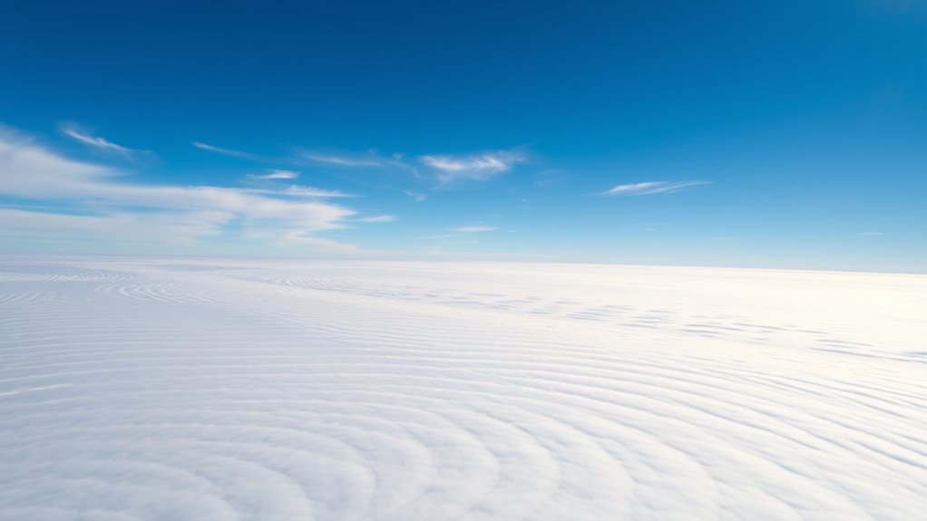
Have you ever looked up and noticed the intricate patterns formed by clouds stretching across the sky? These formations, often called cloud streets, aren’t just beautiful; they reveal essential clues about the atmosphere’s current state. As you observe them, you can begin to understand the underlying dynamics, including signs of convergence and wave formation. Cloud streets typically appear in long, parallel lines, driven by specific atmospheric conditions that create these aerodynamic patterns. When the atmosphere is stable but has enough wind shear, it encourages the development of these elongated cloud formations. Recognizing the patterns can help you gauge atmospheric stability, which is pivotal for weather predictions, aviation safety, and understanding local climate behavior.
The formation of cloud streets hinges on the concept of aerodynamic patterns, which are shaped by the flow of air over a surface. In this case, the Earth’s surface acts as the boundary, and the wind flowing over it creates a pattern of rising and sinking air. When the atmosphere maintains a certain level of stability—meaning it resists vertical movement—these cloud streets become more defined. You’ll notice that the clouds align with the wind direction, indicating that the air is flowing smoothly across the surface without turbulent disruptions. This organized flow often produces the characteristic parallel lines, which are a visual manifestation of the underlying aerodynamic patterns at play. These patterns are not random; they are dictated by the interaction between wind speed, atmospheric stability, and temperature gradients.
Signs of convergence within cloud streets are subtle but observable. When air converges at certain points, it causes localized lifting that enhances cloud formation, often leading to the clustering of clouds along particular lines. Conversely, areas where divergence occurs tend to have fewer clouds or gaps. If you see clouds clustering or appearing to merge along these lines, it indicates convergence zones where air is coming together, lifting moist air and encouraging cloud development. These convergence zones can sometimes signal the onset of localized weather phenomena, such as fog or drizzle. Additionally, the presence of wave-like undulations in cloud streets points to wave formation, which occurs when stable air is disturbed, creating oscillations that ripple through the atmosphere. These waves are often visible as gentle ripples or billows along the cloud lines, hinting at the dynamic processes occurring high above.

Star Cloud 15X55 UHD Lightweight Binoculars for Adults with Upgraded Phone Adapter, Large View IPX7 Waterproof Binoculars for Bird Watching, Hunting, Hiking, Stargazing (15X55)
Powerful Magnification: 15x magnification brings distant subjects up close with exceptional clarity and detail, making it perfect for…
As an affiliate, we earn on qualifying purchases.
As an affiliate, we earn on qualifying purchases.
Frequently Asked Questions
How Do Cloud Streets Impact Local Weather Patterns?
Cloud streets influence local weather patterns by enhancing convection and altering airflow. They can lead to increased cloud cover and precipitation in your area, especially due to aerosol effects that modify cloud microphysics. These streets often signal atmospheric instability, which can bring stronger winds and changes in temperature. Recognizing these signs helps you anticipate weather changes, as the microphysics and aerosols play a key role in shaping how these clouds develop and impact your environment.
Can Cloud Street Formation Predict Upcoming Storm Systems?
Sure, cloud streets are like the weather’s gossip, but don’t bet on them predicting storms just yet. Satellite imagery shows their formation, but wind shear often throws a wrench in forecasts. While these patterns hint at atmospheric instability, they rarely provide a crystal ball for storm systems. You’d need more than just pretty rows of clouds to call the weather shot—think deeper atmospheric clues, not just cloud street runway shows.
What Instruments Are Best for Observing Cloud Street Dynamics?
You should use satellite imagery to observe cloud street dynamics from space, as it provides a broad and detailed view of large-scale patterns. Ground-based observers are also valuable for tracking local changes and capturing real-time data. Combining satellite data with ground observations gives you a holistic understanding of cloud street behavior, helping you identify signs of convergence and wave formation that might indicate upcoming weather changes.
Are Cloud Streets Unique to Certain Geographic Regions?
You might think cloud streets are unique to specific regions, but they appear across many areas, influenced by regional climate and geographic variation. For example, during a trip to the Great Plains, I noticed cloud streets forming regularly over flat terrain, similar to those in coastal zones. While certain conditions favor their formation, these atmospheric patterns are not exclusive to one place—they’re a common feature shaped by local geography and climate.
How Do Atmospheric Conditions Influence Wave Formation in Cloud Streets?
Atmospheric conditions like temperature gradients and aerosol interactions play a pivotal role in wave formation in cloud streets. When temperature differences are strong, they create instability that encourages wave development. Aerosol interactions influence cloud condensation, affecting the cloud’s shape and stability. You’ll notice that these factors work together, intensifying or dampening wave patterns in cloud streets, making them more or less distinct depending on the atmospheric environment.

Field Guide to the Weather: Learn to Identify Clouds and Storms, Forecast the Weather, and Stay Safe
As an affiliate, we earn on qualifying purchases.
As an affiliate, we earn on qualifying purchases.
Conclusion
Just like a skilled sailor reads the wind and waves, you can interpret cloud streets to understand the hidden currents of the sky. These formations are nature’s silent signals, guiding you through unseen forces shaping the weather. By recognizing convergence and wave patterns, you become a navigator of atmospheric stories. Remember, the sky’s calm or stormy whispers are lessons waiting to be uncovered—your journey of discovery is an ongoing voyage through the clouds’ silent language.

Palace Learning 2 Pack – Warm Up Exercises + Stability Ball Exercises – Set of 2 Workout Charts (LAMINATED, 18” x 24”)
Set of 2 Posters
As an affiliate, we earn on qualifying purchases.
As an affiliate, we earn on qualifying purchases.

Sky Atlas for Small Telescopes and Binoculars
As an affiliate, we earn on qualifying purchases.
As an affiliate, we earn on qualifying purchases.